It’s been a while since I last posted. The last week or so has been hectic for me for some real-life reasons, but things are getting back on track and Beta-2 will be out soon for the WM Pro beta testers.
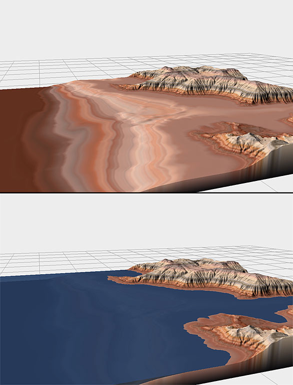
I wanted to post an image of a cool new feature that’s finally made it into WM. People have been asking for a waterlevel plane indicator in WM for ages now, and its a simple but good idea. So I’ve finally added it. It works in all views (Leftside/2D/3D/Layout/Explorer) and simply imposes a waterplane. Not earth shattering, but long since due considering the extreme ease of implementing.
What’s fun though, is that it also inspired me to finally include another Natural Filter into WM. The Coastal Erosion device aims at creating beaches and other natural “water’s edge” features — if you’ve ever taken a fractal terrain and simply flooded it to some level, it looks quite artificial, something like a fjord, not what we usually want. The problem of course is that in nature, water does quite an amazing job of eroding the land that it contacts, turning softer rock into beaches while retaining rocky cliffs elsewhere. A fully-powered Coastal Erosion device would need to run a simulation to achieve many of the effects of coastal action.
The new Coastal Erosion device is nothing but a quick approximation, done without simulation. However, it does a very decent first-approximation to coastal zones.
In the pictures below, the first is without the water plane visible just so you can see the profile of the coastal zone; the second is with the water plane turned on.
13 replies on “Waterlevels, Coastal Erosion device”
Hi,
that looks very promising! Finaly an easy way to make beaches and coastlines.
Regards,
Markus
That is stellar. I have been hating the fjord look for years. I cannot wait for this release. Many, many thanks for all your work.
Magnifique! I especially like the development from a ‘merely’ visual feature (useful though it is!) to something which has added value: coastal erosion> Stephen strikes again! 😀
monks
..and another nice feature 😉
Looking forward to the release.
best,
Walli
This is one cool coastal effect.. and will make beach life easier 🙂
The first image just needs a sunken 16th century galleon there 😉
oh, of course, and the second picture needs a 16th century galleon _floating_ there 😉
Hi, Could you tell us something about the TG2 integration, what i mean is … Will WM terrains load perfectly in TG2? The actual terrains allways need some adjust in the altitude ‘couse they usually load deep into the TG2 world. I allways have to adjust them in the TG 0.9 before load them in TG2.
Ro-nin: yes, this has been fixed.
Looks great , and as Middle Earth has 31864 km of coastline to model, this will surely ease the pain. SeerBlue
The Coastal Erosion addition is very welcome, thanks and keep up the great work.
Excellent!
Maybe it wasn’t rocket science to implement – but it certainly will add a lot to the images we can make. Great work! I have been hoping for something like this for quite a while.
Its really indeed amazing.
Gud work.